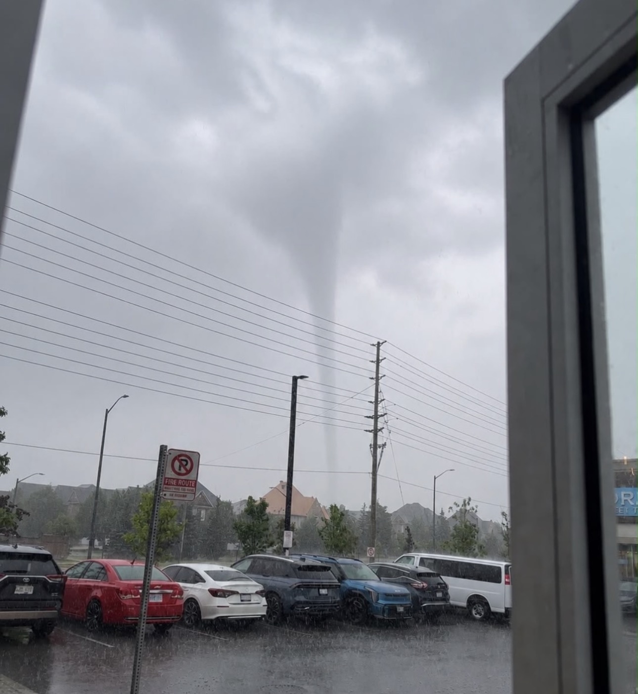
MILTON — A suspected tornado was reported near Milton on Saturday as a rotating thunderstorm crossed Halton Region and moved toward Oakville, Mississauga and western Lake Ontario.
Environment Canada issued an emergency tornado warning at 12:19 p.m., saying meteorologists were tracking a severe thunderstorm “possibly producing a tornado” just east of Milton.
The storm was moving southeast at approximately 40 kilometres per hour. Environment Canada warned that it could also produce wind gusts approaching 90 km/h, large hail and between 15 and 30 millimetres of rain.
Milton, Mississauga and Oakville were identified as communities in the storm’s path.
Photographs and videos circulated on social media appeared to show a narrow funnel extending from the cloud base toward the ground. The accompanying photograph, credited to Toronto Culture on Instagram, shows a tapered condensation funnel visible through heavy rain near a Milton parking lot.
The image alone cannot establish whether the circulation made contact with the ground. A tornado can be in progress even when the condensation funnel is not fully visible, but confirmation normally requires reliable video, eyewitness evidence of debris or a survey identifying a continuous path of tornadic damage.
As of publication, neither Environment Canada nor Western University’s Northern Tornadoes Project had released a formal event classification, path length or Enhanced Fujita rating for the Milton storm.
The event should therefore be described as a suspected or reported tornado until investigators confirm a touchdown.
Warning sent across the western GTA
The tornado alert was delivered to mobile phones across a much larger area than the storm itself.
Environment Canada described the situation as “very dangerous and potentially life-threatening” and instructed people in the warned area to move immediately to a basement, interior room or sturdy shelter.
People without access to a building were advised to lie in a low location and protect their heads from flying debris.
The warning generated reports from residents across Milton, Oakville, Burlington, Mississauga, Brampton and parts of Toronto. Some people outside the immediate storm path received alerts even though conditions at their locations were calm or sunny.
Wireless emergency warnings can be distributed across broad cellular broadcast areas, particularly when a fast-moving storm is approaching a densely populated region. Conditions can also vary dramatically across a warned area.
The tornado warning was followed by a marine tornado warning as the storm approached western Lake Ontario. Reports from Oakville described rapidly darkening skies, heavy rain and visible cloud-base rotation, although those accounts had not been independently verified.
No immediate reports of serious injuries
No serious injuries or widespread structural destruction had been reported by local authorities at the time of publication.
That could change as municipal crews, police and residents inspect the areas beneath the storm’s path. Weak tornadoes can leave a narrow damage trail that is difficult to identify immediately, particularly when they pass through fields, parking areas or places with few structures.
Residents who discover damage should avoid downed electrical lines, unstable trees and buildings with damaged roofs or walls. Photographs should be taken only when it is safe to do so.
Environment Canada asks witnesses to send severe-weather reports to ONstorm@ec.gc.ca or submit them on social media using the hashtag #ONStorm.
What will determine whether it was a tornado?
The Northern Tornadoes Project investigates suspected tornadoes across Canada using ground surveys, drone imagery, satellite information, radar data, photographs and witness accounts.
Investigators look for damage that changes direction across a narrow path, indicating rotation. A downburst, by comparison, generally pushes trees and debris outward or in a largely consistent direction.
If a tornado is confirmed, researchers will assign a rating using the Enhanced Fujita scale. An EF0 tornado has estimated wind speeds between 90 and 130 km/h; an EF1 has estimated winds between 135 and 175 km/h.
A final assessment may take several days, particularly if damage is limited or spread across private property.
Storm developed in a favourable environment
Forecasters had warned before Saturday’s storms that parts of southern Ontario could experience severe thunderstorms, damaging winds, hail and tornadoes.
Warm, humid air near the surface provided energy for thunderstorm development. At the same time, changes in wind speed and direction with altitude created wind shear capable of organizing a storm and producing rotation.
A tornado can develop when a thunderstorm’s rotating updraft tightens and extends toward the surface. The warning issued near Milton concerned a storm moving at 40 km/h, leaving little time for authorities to wait for visual proof before sending an alert.
Milton has experienced tornadoes before
A confirmed EF0 landspout tornado occurred near Milton on July 10, 2020. No injuries were reported in that event.
Milton was also struck during the major southern Ontario tornado outbreak of Aug. 20, 2009. That tornado, rated F1 under the scale then in use, damaged a commercial building, vehicles, power lines, trees and homes.
Saturday’s storm is unrelated to the destructive windstorm that affected Milton and Oakville on July 9, 2026. No tornado was confirmed in the immediate reports from that earlier event.
Confirmation still to come
The photograph and eyewitness accounts provide credible reason to investigate Saturday’s storm as a possible tornado. Environment Canada’s warning confirms that meteorologists detected a thunderstorm capable of producing one.
They do not, by themselves, provide a final scientific confirmation.
The key outstanding questions are whether circulation reached the surface, where the damage path began and ended, how long the tornado remained on the ground and what maximum wind speed can be inferred from the damage.
Until those questions are answered, the most accurate description is that a tornado was reported or suspected near Milton during a tornado-warned storm.
Sources
Details remain subject to revision as officials assess the event.